DOCTOR DISK |
||||
| Contact Details | ||||
 |
||||
| For Data Recovery see ESS Data Recovery and mention Dr Disk, Reseller # 1024, to receive a discount and a free hard disk. | ||||
| Making Money on the Web - My thoughts on it. | ||||
| Current Virus Information | ||||
| Virus Tracking Page | ||||
 |
||||
| Services | ||||
| Information | ||||
| Warranty Information | ||||
| About the Company | ||||
| About Phil Smith | ||||
| Travels by Motorbikes and Sidecars | ||||
| Motorbikes and Sidecars Chang Jiang 750, CJ750 |
||||
| Riding With Purpose - Motorbike Podcasts | ||||
| Statement of Faith | ||||
| Family Photographs | ||||
| Journey to the West | ||||
| Phil's Resume | ||||
| ACA, ACoA, Adult Children | ||||
| Adoptive Families of Hong Kong | ||||
| Hot Pages | ||||
 |
||||
| Phil's Typhoon Page | ||||
| Handy HK Links | ||||
| Back to Home Page | ||||
 |
||||
| 31/10/98 |
||||
| Australian Motorcycle Tours | ||||
|
Severe Hybrid Tropical Storm SE Queensland, March 2004
Overview
E-mail descriptions and eye-witness reports
BoM Preliminary Report
Overview:
On the morning of 2nd March 2004, Jeff Callaghan of BoM Brisbane alerted us to an unusual development in the Coral Sea. The storm that grew out of it over the next few days was tropical in nature, had gale-force winds, but never quite managed to form into a tropical cyclone and earn a name. By 6th March over 100,000 people were without electrical power, trees had been flattened across SE Queensland, there were many reports of flooding, and a great deal of disruption to normal everyday life. This page should be viewed at 1024 x 768 or higher resolution to avoid strange formatting of the graphics. Satellite pictures (satpics) on this page are copyright Bureau of Meteorology. Annotations and colourised satpics are copyright Carl Smith. Satpics should appear to the right of the subject line of the e-mail referring to them. Timestamps in Satpic filenames all refer to UTC. E-mail times on this page are in the American date format (Month/Day/Year) and are all in Hong Kong Time (UTC+8).
Descriptions:
The following snippets from e-mails written by a mixture of experts and amateurs give a blow-by-blow description of the life of this unusual storm. Actual e-mail addresses have been edited out as have many comments on other simultaneous storms and the many pages of HTML code that was being sent back and forth as some of us tried to keep up with maintaining coverage of this storm on our web-pages. Material deleted within the body of an e-mail is denoted by [snip].
From: Jeff Callaghan To: TROPICAL CYCLONES DISCUSSION GROUP [TCDG]
Date: 03/02/2004 09:04 Subject: unusual Coral sea development
For those who like unusual events watch the Coral Sea for the rest of the week as
most models now intensify a tropical low and move it towards the Qld coast and beneath a
500hPa low near the Tropic of Capricorn.
In the EC +48h for 12Z 3 Mar 2004 there is extremely strong warm air advection
on the poleward side e.g. the grid near 17.5S 155.0E has SE/60knots at 850hPa, E at 50
knots at 700hPa and NE 55 knots at 500hPa. This is followed by rapid deepening as the
models move it towards the Qld coast. These cyclones usually have a sheared appearance on
Satellite imagery but can reach hurricane force. Examples are Kelvin in Feb 1991 which hit
Willis Island and the unwarned Tropical cyclone which struck the Sunshine coast New Years
day 1963.
Jeff
From: Simon Clarke To: TCDG
Date: 03/02/2004 15:49 Subject: Re: unusual Coral sea development
Jeff...
I sent a message to the Group a few days ago regarding Cyclones south of about Lat
25 and said that they tend to shear away rapidly upon reaching this point.... This
particular storm appears in you description to fit the mould....
I'll be watching carefully....
Regards
Simon
From: Carl Smith To: Phil Smith
Date: 03/02/2004 23:19 Subject: current.htm - Qld system added
Hi Phil.
[snip] added Qld system, etc.. Will have to consider what radar links to add [snip] for
the new one developing in the Coral Sea and headed for here.
ABC TV News weather report tonight told us to expect "gale to storm force winds"
for SE Qld coastal districts on Friday.
Carl.
From: Carl Smith To: TCDG: ;
Date: 03/03/2004 13:56 Subject: Coral Sea satpic 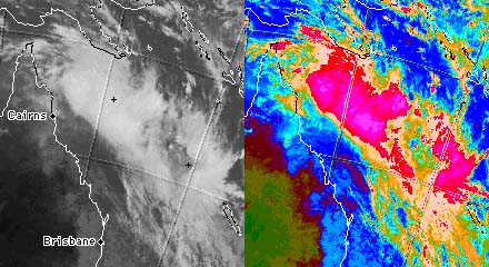
Hi All.
As shown in the BoM IR satpic below, the Coral Sea low has developed two LLCC's, with the
stronger one being ENE of Cairns and a weaker one NNE of Brisbane - it will be interesting
to see how these two develop and perhaps interact.
I approximated the LLCC positions with crosses as given in the BoM High Seas Gale Warning
issued at 01:49Z:
SITUATION
A complex area of low pressure with two centres one low 1000 hPa located near 14S151E at
030000Z and another low 1002 hPa located near 18S159E are expected to deepen and move
slowly south over the next 24 hours. A large 1030 hPa high is located over the Tasman Sea
and is moving slowly east.
The 2nd LLCC could be a little S or SW or W of the cross, however it is hard to tell on
the satpic.
Regards,
Carl.
From: Carl Smith To: "Phil Smith"
Date: 03/03/2004 22:44 Subject: Re: current.htm - Coral Sea Low - many new links
[snip]
Been blowing a gale here for most of the day.
BoM seems to be holding off on specific public warnings for Coral Sea system(s) - I guess
the elusive multiple LLCC's are playing cat-and-mouse and they are not quite sure when and
where it will all spin up - according to BoM on ABC radio late this arvo, there were at
least 3 LLCC's and possibly more, and the models all agree that SE Qld is still going to
get clobbered Friday, but they do not agree what path, with some showing a LLCC hitting
Fraser Is and travelling inland to Darling Downs and others showing a LLCC approaching
Fraser Is then turning S and hugging the coast - either scenario means gale to storm force
winds here Friday, the first one meaning flood rains as well.
[snip]
Carl.
From: Carl Smith To: TCDG: ;
Date: 03/04/2004 00:24 Subject: Coral Sea satpic 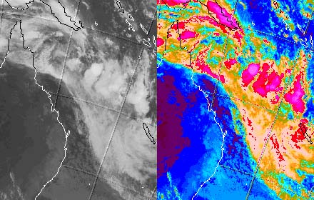
Hi All.
The mess in the Coral Sea must be keeping the Brisbane BoM busy - see satpic below.
Regards,
Carl.
From: Roger Edson To: TCDG
Date: 03/04/2004 02:47 Subject: Re: Coral Sea satpic
This looks like our reverse-oriented monsoon trough that we often get in the
NWPAC. With this, you can get several small TCs popping within the (and going down) the
trough....and then possibly one larger one to clear everything out. Hey about it Mark L?
Roger
From: Carl Smith To: TCDG: ;
Date: 03/04/2004 09:58 Subject: Coral Sea satpic 2004-03-03 21:30 utc 
Hi All.
According to the BoM, a tropical low is going to develop out of the mess in the satpic
below and head for SE Qld.
One is left to speculate as to why the BoM is issuing Severe Weather Warnings rather than
Tropical Cyclone Advices for an apparently tropical system with winds forecast to have
gusts of 120 km/hr near the centre as per their SWW - will this be another 'duck'?
Regards,
Carl.
From: "Phil Smith" To: "Carl Smith"
Date: 03/04/2004 10:18 Subject: Re: current.htm updated
Hi Carl,
[snip]Also added Monterey and FNMOC lines to QLD Low.
Do you reckon JTWC are ever going to notice the Coral Sea low? They are still lingering on
no disturbances for the Pacific.
How's the wind and weather?
Phil
<><
From: Roger Edson To: TCDG
Date: 03/04/2004 10:32 Subject: Re: Coral Sea satpic 2004-03-03 21:30 utc
Carl,
I think this is a difficult area to forecast and to specifically 'pinpoint' a location to
watch out for...
To me, an area-wide gale and/or storm area at this time is the best way to describe the
area. Once (if) the region consolidates into a unique area that can be identified, then
(it seems to me) that a TC warning would become appropriate.
Otherwise, you will end up chasing either 'false centers' or missing fast moving ones that
move down the trough axis. And, you still will not be adequately representing the
destructive wind area.
Roger
From: Simon Clarke To: TCDG:
Date: 03/04/2004 11:32 Subject: Re: Coral Sea satpic 2004-03-03 21:30 utc
Carl...
The latest sat pictures clearly show the cloud line moving steadily toward the coast.
It looks as though it will wrap up into a sub-tropical storm.... (ie - gales may not be
present in the northern quads and may be displaced away to the south east of the centre).
This initial sub-tropical storm may then develop some semblance of full tropical
characteristics if the wrap is quick and strong enough. The new low is forecast to be 990
hpa by tomorrow..... with gales averaging between 40 and 50 knots between 1770 and Cape
Moreton ..... so I think Sub-Tropical Cyclone Grace would be a nice name for this one (or
Sub-Tropical Storm Grace)..... For all
intents, it will seem like a cyclone on the southern side ....
Cheers
Simon
From: "Mark A. Lander" To: TCDG
Date: 03/04/2004 12:04 Subject: Re: Coral Sea satpic 2004-03-03 21:30 utc
Hi Simon,
This one will indeed be an interesting cyclone to follow. Two numerical models that I
looked at are slightly different on the track. The U.S. Navy model (NOGAPS) wraps the
system up nicely and brings it inland in SE Australia. The U.S. National Met Center (NCEP)
model (GFS) wraps it up very tightly, but keeps it just off-shore on its southward run.
Nice forecast challenge. Hope all are braced for the wind, waves and heavy rain.
A warm dry "winter" day here on Guam,
Mark Lander
From: Carl Smith To: "Phil Smith"
Date: 03/04/2004 12:25 Subject: Re: current.htm updated - Qld changes
Hi Phil.
Forecast 130 km/hr here tomorrow.
[snip]
Qld changes:
BoM Qld: 1:45 pm AEST [UTC + 10h]: Severe Weather Warning: Town of 1770 to Coolangatta
BoM NSW: 2:35 pm AEDT [UTC + 11h]: Severe Weather Warning: Qld. border to Coffs Harbour
[snip]
Carl.
From: Carl Smith To: TCDG: ;
Date: 03/04/2004 15:27 Subject: Coral Sea Satpic 2004-03-04 03:30 utc 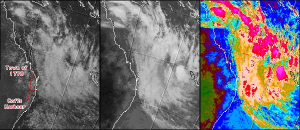
Hi All.
The Coral Sea mess is fast getting organised, and the scenario forecast by the BoM
certainly does appear to be unfolding.
The composite BoM satpic below has the Vis image LHS, IR centre, and coloured IR RHS.
I have also marked the area of coast under Severe Weather Warnings by BoM Qld & NSW in
red on the Vis image - the area in Qld stretches from the Town of 1770 and the tip of
Fraser Island in the N to Coolangatta on the border, and in NSW from the border S to Coffs
Harbour.
According to BoM on ABC radio Brisbane a few minutes ago, the most destructive winds will
probably reach the tip of Fraser Island in the early hours of Friday and progress S to the
Sunshine Coast during the early morning, and continue beyond Brisbane during the day
reaching the Gold Coast during the afternoon, contracting S into NSW during Saturday
morning.
Regards,
Carl.
From: Simon Clarke To: TCDG:, ;
Date: 03/04/2004 16:44 Subject: Re: Coral Sea Satpic 2004-03-04 03:30 utc
Carl and others....
From those pictures, you can just about see the new low starting to take shape (lighter
and strong pink tones).... with a definite southern and eastern side bias .. a SW track
will bring the worst of this weather through the Hervey Bay area of QLD first and then
southwards ....
There is a remarkable amount of tropical energy being wrapped southwards by the new low
... ... hence the potential for rather severe weather conditions on the southern side of
the system...
Already getting grey and grizzly here in Bayside Brisbane ! Squally showers now coming
through with more regularity ...
Cheers
Simon
From: Carl Smith To: TCDG: ;
Date: 03/04/2004 19:12 Subject: Coral Sea 2004-03-04 06:30 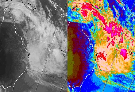
Hi All.
The Coral Sea system is continuing to organise. You can see that the wrapping mentioned by
Simon has continued, and the cloud is starting to move on to the coast.
The weather here on the Gold Coast is alternating between calm and squally showers with
near gale force winds.
Regards,
Carl.
From: Carl Smith To: TCDG: ;
Date: 03/04/2004 22:11 Subject: Coral Sea satpic 2004-03-04 11:30 utc 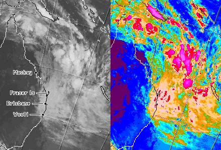
Hi All.
The Coral Sea situation is unfolding - a BoM senior forecaster on ABC radio Brisbane said
at ~10:05 pm AEST [UTC+10h] that a low has developed about 800 km E of Mackay, and it is
expected to quickly deepen and move rapidly SW to be a little NE of Fraser Island about
noon AEST.
Another BoM update via ABC radio at ~11:05 pm AEST said much the same as above, and that
the low is about 700 km NE of Fraser Island and is expected to move SW at about 40-50
km/hr.
It is remarkably calm here on the Gold Coast at the moment, with just light breezes.
Latest BoM Severe Weather Warnings pasted below the satpic.
Regards,
Carl.
From: Carl Smith To: TCDG: ;
Date: 03/05/2004 00:38 Subject: Coral Sea satpic 2004-03-04 15:30, paraphrased
description by Jeff Callaghan BoM 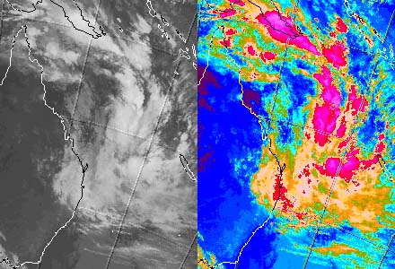
Hi All.
I just heard group member Jeff Callaghan of BoM Brisbane on ABC radio giving one of his
simple yet clear descriptions of the Coral Sea low as a hybrid system with tropical
characteristics coupled to an upper system of more mid-latitude characteristics. He said
SST's of around 28C are fueling it, whilst it is being steered by an upper low centred
overland near Charleville Qld, giving it a fairly predictable path towards the Fraser
Island area. He also said AWS info coming in from Fredericks reef in the Swain group was
giving them good information as to whats happening out there, where thunderstorm activity
has increased. He also said gales exend all the way out to New Caledonia.
Keep up the good work Jeff - your clarity is much appreciated.
BoM IR satpic + colourised version below - you can see how the thunderstorm activity
[magenta] has increased significantly in the last few hours as the low develops.
Regards,
Carl.
From: Carl Smith To: "Phil Smith"
Date: 03/05/2004 07:27 Subject: RE: current.htm updated
Hi Phil
[snip]
>Hi Carl,
>I see winds at Gold Coast Seaway this morning are blowing at 92 km/h.
>Hang on tight when the worst approaches you later today!
Yes, it is windy here at times - Sheila has gone out to stock up on a few things
As it has slowed it's forward motion, it may become a TC before landfall The TC Warning
signal is sounding with every warning on the radio now, so the BoM has decided it is
better to play safe, which they were not doing till this morning.
BTW, did you happen to save a copy of the 5am warning? I slept through that one! I have
all the others, as Gary will probably want them when he writes this up.
[snip]
Carl.
From: "Phil Smith" To: Carl
Date: 03/05/2004 09:13 Subject: current.htm QLD + NSW SWWs updated
Hi Carl,
[snip]BoM Qld: 10:50 5/3 AEST [UTC + 10h]: Severe Weather Warning: Rundle Is to
Coolangatta and 120 km Inland.
BoM NSW: 12:00 5/3 AEDT [UTC + 11h]: Severe Weather Warning: Qld. border to Wooli.
Phil
<><
From: Carl Smith To: TCDG: ;
Date: 03/05/2004 09:52 Subject: Coral Sea satpic 2004-03-04 22:30 utc 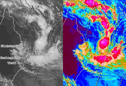
Hi All.
The hybrid system in the Coral Sea has developed a quite tropical looking centre as it
strengthens - see satpic below.
The BoM Qld has a Severe Weather Warning for the coast between Rundle Island near
Gladstone to Coolangatta on the border extending 120 km inland, and NSW BoM has a severe
weather warning from the border to Wooli, as marked on the satpic.
In case some of the newer members are wondering, I am on the Gold Coast about 14 km NE of
Coolangatta, Simon is in the E suburbs of Brisbane, Michael Bath is a little SW of
Coolangatta near Lismore in NE NSW, and Jeff Callaghan is at the BoM Brisbane, not sure
where he resides.
Latest Severe Weather Warnings pasted below the satpic.
Regards,
Carl.
From: Simon Clarke To: TCDG:, ;
Date: 03/05/2004 10:14 Subject: Re: Coral Sea satpic 2004-03-04 22:30 utc
Carl and others ...
I am surprised at the size of this system.... I was expecting is to become more compact
and that may happen in you next pictures as the clouds wrap in around the low.... Rain is
comining down now and the radar shows it moving over in spiral shaped bands.... winds are
just starting to get up there (I'd say 25 - 33 knts) at the moment......
I suspect in days gone by (and before Sat pics etc...) that this would have been
considered a tropical cyclone ....
My biggest concern is for a significant flood event .... we have had quite a wet summer
here this year, for a change !!!!!!!!
Regards
Simon
From: Carl Smith To: TCDG: ;
Date: 03/05/2004 12:28 Subject: Coral Sea satpic 2004-03-05 00:30 utc 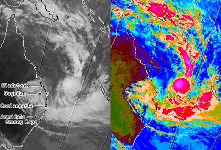
Hi All.
The Coral Sea system continues to show increasing organisation in the satpic - the main
locations mentioned in the SWW's I sent earlier have been added.
Conditions here on the Gold Coast are alternating between relative calm and squally
showers with gale force winds - the strength of the winds a the frequency of the squalls
has increased quite a bit over the last few hours.
Regards,
Carl.
From: "Phil Smith" To: Carl
Date: 03/05/2004 12:36 Subject: current.htm - QLD SWW updated to 13:47
Hi Carl,
[snip]BoM Qld: 13:47 5/3 AEST [UTC + 10h]: Severe Weather Warning: Rundle Is to
Coolangatta and 120 km Inland.
Phil
<><
From: "Phil Smith" To: Carl
Date: 03/05/2004 15:16 Subject: current.htm - QLD & NSW SWW updates
Hi Carl,
[snip]BoM Qld: 16:50 5/3 AEST [UTC + 10h]: Severe Weather Warning: Within area from Double
Island Point to Kingaroy to Stanthorpe to Coolangatta.
BoM NSW: 18:10 5/3 AEDT [UTC + 11h]: Severe Weather Warning: Northern Rivers, the Northern
Tablelands and the Mid North Coast north of Smoky Cape.
You've been quiet for a while ... lost power or taking a rest?
Phil
<><
From: Carl Smith To: TCDG: ;
Date: 03/05/2004 15:31 Subject: Coral Sea satpic 2004-03-05 03:30 utc 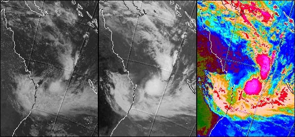
Hi All.
The Vis-IR-IRcol composite from BoM satpics below shows what appears to be an elongated
LLCC just off the tip of Fraser Island extending NE.
ABC News reports say over 20,000 homes are without power in the Greater Brisbane area, the
Sunshine Coast, and the Gold Coast. There are reports of trees down, about 40 homes have
suffered roof damage on the Gold Coast.
Here on the Gold Coast, it is raining continuously, the park adjacent to us is flooded,
and the winds have been near gale force with stronger squalls thrashing the trees about
for the last few hours - I should mention that we are exposed on a rise here, so it is
probably not as wild in flatter areas.
Latest SWW's pasted below.
Regards,
Carl.
From: Simon Clarke To: TCDG
Date: 03/05/2004 16:23 Subject: Re: Coral Sea satpic 2004-03-05 03:30 utc
Carl and others
To confirm.... a quick trip to Cleveland Point this afternoon revealed quite a lot of tree
damage (much more than I expected) with several areas carpeted with leaf
litter.............the rain is continuous and in torrents.
I have 85mm in the last three hours although this is suspect due to the wind and
vegetation nearby....
I think flooding is a real threat now... another ten to twelve hours ahead of us .....
Cheers
Simon
From: Carl Smith To: TCDG: ;
Date: 03/05/2004 18:47 Subject: Coral Sea satpic 2004-03-05 06:30 utc 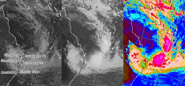
Hi All.
Wild weather continues here on the Gold Coast - the rain is bucketing down and the wind is
blowing gale force much of the time, with the stronger gusts thrashing the trees about in
our somewhat exposed location. Just before dark, the park adjoining our place was looking
more like a lake, with more water there than I have seen since living here.
ABC News says that whilst crews are working hard to restore power, 22000 homes are still
blacked out in SE Qld, and more are expected to lose power over the next few hours on the
Gold Coast as the strongest winds contract south - our lights here have flickered many
times this evening, however the last hour has seen it happen far more frequently than
before.
The Vis-IR-IRcol satpic has the changed Qld warning places (and the old NSW ones) on it.
Latest BoM Qld SWW pasted below that.
Regards,
Carl
From: "David Roth" To: TCDG
Date: 03/05/2004 21:25 Subject: Re: Coral Sea satpic 2004-03-05 06:30 utc
Now that's looking more like a subtropical storm...though without obs it's hard to tell if
that "tail" extending N and NW of the center is a front or merely a surface
trough. =)
If what I've seen in the ST candidates in the Northern Hemisphere works out similarly down
south, then your peak months for these systems should be March and April...so it's right
on schedule.
DR
From: Roger Edson To: TCDG
Date: 03/05/2004 21:31 Subject: Re: Coral Sea satpic 2004-03-05 06:30 utc
I really tried to get JTWC to start a 'suspect area' over this area--for research, anyway.
But, they started one (I think it was 95P) then dropped it--with the change of shift. I
wanted to record the MI images for this kind of 'subtropical-type' system. It seemed to
have a good sig a 37Ghs but definitely NOT a good (circular) 85h signature (as one would
expect for a bonafide TC).
roger
From: "Gary Padgett" To: TCDG
Date: 03/05/2004 22:03 Subject: Re: Coral Sea satpic 2004-03-04 22:30 utc
Simon wrote:
>I suspect in days gone by (and before Sat pics etc...) that this would have been
considered a tropical cyclone ....
I quite agree. This has been a feeling of mine for many years. While satellite coverage
has in the main caused the apparent total number of TCs to increase by spotting them in
data-poor sections of the oceans, the attempt to estimate TC intensity from satellite
imagery, first from some of the pre-Dvorak methods and then from Dvorak, has led to a
focusing in on systems with well-
organized central convection like the "classic" deep-tropics brand of TC and to
the exclusion of systems like subtropical cyclones (STCs) and monsoon depressions (MDs).
I have little doubt that in pre-satellite days many STCs and MDs were treated as tropical
cyclones and named if and when winds exceeded gale-force.
From: Carl Smith To: Phil Smith
Date: 03/05/2004 22:12 Subject: current.htm updated - details below
Hi Phil.
[snip]BoM Qld: 23:08 5/3 AEST [UTC + 10h]:Severe Weather Warning: Caloundra to Kingaroy to
Stanthorpe to Coolangatta.
BoM NSW: 23:55 5/3 AEDT [UTC + 11h]: Severe Weather Warning: Qld. border to Seal rocks
incl Northern Tablelands.
[snip]
Also removed NSW Coast Wind 2 link, but guess it will be reinstated tomorrow sometime.
[snip]
Carl.
From: Carl Smith To: TCDG: ;
Date: 03/05/2004 22:26 Subject: Coral Sea satpic 2004-03-05 09:30 utc 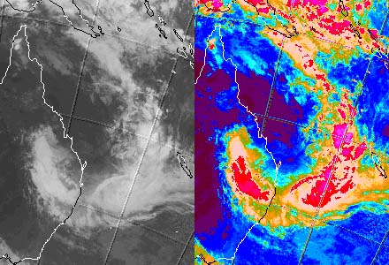
Hi All.
It's still bucketing down on the Gold Coast, although we had a 20 min period without rain
from about 10pm AEST [UTC+10h] after about 6 hours continuous heavy rain, which gave me a
chance to get outside. The wind was alternating between a stiff breeze for a few minutes,
then suddenly gusting through and thrashing the trees about for many minutes. There are
leaves and small branches strewn around the place, but I will have to wait until daylight
to have a better look.
I think the strongest winds have probably moved through now, although it's still blowing a
gale outside and some of the squalls are quite fierce. Like Simon, I expect there will be
a some flooding coming from this event given the sustained heavy rains - one consolation
is that the Hinze Dam, which is the water supply for the Gold Coast, will get enough water
from this event for our water restrictions to be lifted!
Satpic and latest BoM SWW's below.
Regards,
Carl.
From: Simon Clarke To: [TCDG]
Date: 03/05/2004 22:45 Subject: OK enough !
Well it's about quarter to one in the morning .... I thought the worst was gone several
hours ago....
But I must admit the gale is stronger than ever ........ there is going to be quite a lot
of damage especially along the coast line.
There are large gum trees in my neighbourhood and they are really being blown to bits at
the moment. Can't see if any have fallen but I don't really want that to happen. We had a
very severe thunderstorm about four weeks ago that felled and split many trees. This is
worse as it is lasting longer and the winds would be about 40 - 50 knots - average now ...
and I am in a reasonably sheltered spot about 1 km from Moreton Bay.
That might not seem like much to you hardened cyclone chasers ... but believe me when it
is right over your house it probably seems much much worse ...
It has just gone calm ... so may that is it ... I have had enough !
Cheers
Simon
(PS - surprised the power is still on!)
From: Carl Smith To: TCDG
Date: 03/06/2004 00:22 Subject: Re: Coral Sea satpic 2004-03-04 22:30 utc
The experiential aspect on the ground of this one is very similar to a Cat 1 or weak Cat 2
(Aust) tropical cyclone except for the very long duration of the severe weather - if one
was stuck in the middle of nowhere without outside contact, getting clobbered by a very
large cyclone would be a natural conclusion to draw from the conditions.
One good point about the BoM warnings via the media is that throughout Friday they have
been using the emergency signal that until recently was reserved for tropical cyclones,
and I think this
was a good decision, as prior to the signal being sounded with the warnings some in the
commercial media were not taking the threat of this system very seriously at all, which
could have lulled many who may not understand what "wind gusts to 130 km/hr"
really means into a false sense of complacency.
Regards,
Carl.
From: Carl Smith To: TCDG: ;
Date: 03/06/2004 00:49 Subject: Coral Sea satpic 2004-03-05 15:30 utc 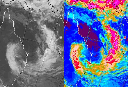
Hi All.
According to BoM on ABC radio in the last few minutes, the low causing all the gales has
more or less been stalled for several hours now NW of Gympie (diamond on satpic is Gympie)
and is expected to drift slowly S, extending the period of severe weather being
experienced here into Saturday morning - it is still blowing a gale.
They are also concerned because tide instruments are showing that the tide is about 0.4
metres above normal, so the high tide after sunrise combined with the easterly gales could
cause innundation in low lying areas, which may cause some problems for some.
[snip]Regards,
Carl.
From: Simon Clarke To: TCDG
Date: 03/06/2004 04:33 Subject: Re: Coral Sea satpic 2004-03-05 15:30 utc
Carl....
The high tide at Cleveland Point appears to have gone over the car park area - waves
mainly ... but the weather conditions eased significantly here during the early hours....
I must say I have not seen a gale quite as strong as that here where I have lived for many
years ..... I'd say a minimal Cat 2 cyclone strength.
I had expected to see more damage around the place...... I didn't see any structural
damage .. but quite a few tree limbs have fallen as you would expect....
Cheers
Simon
From: Carl Smith To: TCDG: ;
Date: 03/06/2004 09:55 Subject: Coral Sea satpic 2004-03-06 00:30 utc 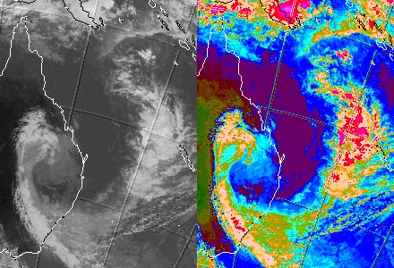
Hi All.
Conditions here have settled right down and the Severe Weather Warning for SE Qld has been
cancelled.
Below is the last of this series of images.
Regards,
Carl.
From: Dale Small To: aussie-weather
Date: 03/06/2004 16:42 Subject: Re: aus-wx: Brisbane wx
After 27 and a half hours without mains power, all i can say is "thank god" im
back on the grid again.
Lots of damage around the Park Ridge to Beaudesert district, some BIG trees down, many big
branches down, some closing off the only route south last night (highway 13, Mt Lindsay)
as far as im lead to believe, Cunninghams Gap
was still closed off earlier thisafternoon.
Rainfall was just absurd last night, I left the car down the front and waded through waist
deep water @ midnight with no power to get back up to the house.. it has receeded enough
to drive right up what is left of the driveway. (And what is left of our trees)
There is a lot of cleaning up to do after this one!
*Dale*
From: Carl Smith To: TCDG: ;
Date: 03/06/2004 23:32 Subject: False - cyclone overland 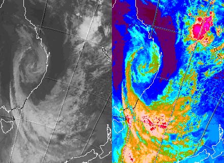
Hi All.
Simon emailed me suggesting I get the latest satpic and send it to the group as it:
"Looks like a false - cyclone overland", so it's below.
Certainly is an odd pic for this part of the world!
Regards,
Carl.
From: Carl Smith To: TCDG: ;
Date: 03/06/2004 23:39 Subject: SE Qld recovering from storm battering.
Hi All.
Damage here from the battering amounts to leaves and branches up to 1cm strewn around the
place, a neighbour had two plants on pedastels blown over and smashed, went for a walk and
there were some branches up to 2 inches snapped off - all considered we fared pretty well.
Many were not so fortunate - ABC news said there was one death of a 10 year old who was
washed away while trying to walk across a flooded causeway in NE NSW, and many others were
rescued from vehicles washed away trying to cross flooded causeways. There was some roof
and water damage on the Gold Coast, mainly to houses already damaged from the intense
hailstorm a couple of months ago and some from trees falling on houses, and some water
damage from rising floodwaters entering homes. Around SE Qld, many trees are down
including some blocking roads, there are widespread power failures with crews working hard
to restore power, having reduced the number of homes without power from 105,000 early Sat
morning to about 25,000 by evening.
Regards,
Carl.
From : Matthew Saxby To : TCDG
Sent : Saturday, March 6, 2004 11:50 PM Subject : Qld-NSW Subtrop turns killer
Dear All,
Two people have lost their lives as a result of the just-finished STS -- a 10-year-old boy
who was drowned after being swept away from his family when they tried to cross a creek in
the Tweed River catchment; and an elderly woman drowned in a creek near Nambucca Heads (S.
of Coffs harbour, NSW). In addition, two girls aged 12 and 13 were pulled into the river
(would that be the Bremer or the Brisbane?) on Saturday a/noon at Bundamba, between
Brisbane and Ipswich, and had to cling to a branch to avoid getting swept away. They were
rescued by police. There have been numerous emergency calls, but most have related to
fallen trees, with only minor structural damage occurring. Minor to moderate flooding is
occurring or has occurred in the Mary and Albert-Logan (Qld), and the Tweed, Richmond, and
Bellinger Rivers (NSW). In addition, the Hinze Dam behind the Gold Coast has risen from (I
think) 7.90m (or 7.09) below the spillway to only 3.92 below since Friday evening. (What
percentage is it filled to now, Gold Coasters? Certainly an improvement on the 32% it was
just over a year ago!).
BTW, those who have better skills than mine in analysing satpix &c...would this storm
have been named as an STS had it been in the Atlantic? I am beginning to think we in
Australia might have to move toward naming STS's American-style in order to get the
message across that these babies are DANGEROUS, particularly as they seem to have replaced
the true TC in our part of the world. Dramatic as Severe Wx Warnings can be, I don't think
they quite pack the punch of true TC or STS warnings, and I certainly concur with the use
of the Emergency Warning Siren (as reported by Carl) in instances such as this weekend's.
BTW2: Rain from the STS fell in Canberra this afternoon, but I don't think it amounted to
much :(
Matthew
From : Carl Smith To : TCDG
Sent : Sunday, March 7, 2004 12:15 AM Subject : Re: Qld-NSW Subtrop turns killer
Hi Mathew and All.
[snip]
The Sat evening Ch 7 News said the Hinze Dam was 79% capacity with lots of water still
flowing in after heavy rains through most of Friday night in the catchment - the high
country behind the Gold Coast copped the brunt of the severe weather between 10pm Fri and
3am Sat - our water restrictions will finally be lifted at the next Gold Coast City
Council meeting in a few days. Some good follow rains in coming weeks could see it finally
reach 100% after several years of the worst drought on record here - it is raining lightly
here now, but nothing like what got dumped here last night.
Regards,
Carl.
From: Carl Smith To: TCDG
Date: 03/07/2004 01:24 Subject: Re: Qld-NSW Subtrop turns killer
Hi Mathew and All.
[snip]
Whilst there is certainly a strong case for developing a specific sub-tropical storm
warning system, and perhaps even for naming them to draw public attention to them, having
experienced this one, I now realise the wisdom of NOT issuing standard cyclone type
warnings for this kind of event, although I would have said different a couple of days
ago.
The Severe Weather Warnings combined with the use of the emergency signal on Friday was
adequate, as it enabled good discussion in the media of the difference between this storm
and a 'normal' cyclone, i.e, the fact that unlike a tropical cyclone where winds are most
severe near the centre, the severe weather in this storm was a long way south of the
'main' centre (there were several centres at various times, so it was sometimes a bit
difficult to pinpoint a particular one) - people up in the Wide Bay area where the 'main'
centre crossed the coast did not get much in the way of severe weather - it was the area
from the Sunshine Coast to NE NSW that really copped a battering, and from damage reports
in the media, the most severe weather of the event was probably on the Gold Coast
hinterland 10pm Fri to 3am Sat when the 'centre' was nearly stationary overland around 200
km away to the NW of Gympie, a very different situation to what would happen in a 'normal'
cyclone.
When you look at the satpics, the really rough weather was mainly under the 'hook' of
cloud to the S.
My only criticism is that the emergency signal should have been sounded with the warnings
from around midday Thursday instead of waiting until Friday morning, as if Thursday's
forecasts had panned out, many peoples first inkling that all hell was going to break
loose would have been waking up to near storm force winds Friday morning when it is too
late to make adequate preparations, and this was a very real risk as some in the
commercial media who should have known better were not treating it very seriously at all
on Thursday - I listen to ABC radio 612 Brisbane or ABC Coast FM on the Gold Coast most of
the time, and they both did a pretty good job throughout the whole period.
It's a good thing that the system developed more slowly than initially forecast, as it
gave time for people to prepare Friday morning when the emergency signal WAS being sounded
with the warnings and the commercial media finally woke up that things were likely to get
dangerous.
I think the BoM should be commended for the way they handled the situation, both for the
quality of the warnings and their handling of the media - the use of the emergency signal
in this kind of situation is apparently not their decision, they have to wait until
instructed by another body, perhaps EMA, to include in the header of the warnings the
instruction for the media to sound it.
Regards,
Carl.
From: Roger Edson To: TCDG
Date: 03/07/2004 07:21 Subject: Re: Qld-NSW Subtrop turns killer
Hi,
I just went back and looked at Phil Smith's excellent recap of events for this
system--nice job! Anyway, I don't think I could have ever warned on it based on the
Subtropical Cyclone criteria. The central low pressure area never had a good enough deep
convective signature...
But now, I'm thinking ...that this might have fit possibly into Mark Lander's Monsoon Gyre
definition. I would like to see a set of 12-hourly pressure and wind field analyses to be
sure. For sure, the origin was NOT in the mid-latitutes or subtropics---but in the tropics
(even for the SH). I think there were several low pressure areas within the tail/trough
region (look at the circular convection just east of the big low).
In Mark's gyre description, the central low pressure region often does not have any deep
convection (it may at the end of its life as a final consolidation).
Anyway, just an idea--but still not sure how to warn on it and how to classify it
properly.
Roger
From: Michael Bath To: TCDG
Date: 03/07/2004 08:24 Subject: Re: Qld-NSW Subtrop turns killer
Hi all,
The most severe weather occurred from 6pm Friday onwards on the NSW North Coast, with
winds peaking locally between 1am and 3am Sat. Cape Byron measured a few gusts over
100km/h, though received a lot less rain than observing sites just inland from the coast:
http://www.BoM.GOV.AU/products/IDN65092/IDN65092.94599.shtml
We lost power at 2.15am and it was not restored until 2.30pm - over 12 hours which is very
annoying when relying on electric pumps for water ! (I live out of town). Rainfall fell at
a rate of about 20mm/hour for about 6 hours to 1am - then eased, with the 24 hour total of
152mm - though the bulk of it fell in just 8 hours.
Yesterday afternoon I toured around the Lismore district to see the extent of flooding and
any damage. Around my area (20km SW of Cape Byron), some trees had been brought down with
many large (30cm diameter) branches snapped off, and leaf and trig litter was everywhere.
Quite a number of roads were cut by floodwaters, and the main rivers were rising quickly
in Lismore itself with a river peak of 7.5 metres expected last night (this is a moderate
level and only inundates lower parts of the city).
I estimate winds reached 90 to 100 km/h at my property late Friday night and early
Saturday morning. Winds veered from SE to E then NE (as the rain cleared) during the
event, with quite strong northerlies during Saturday with mainly fine conditions.
cheers, Michael
From: Simon Clarke To: TCDG
Date: 03/07/2004 10:51 Subject: Re: Qld-NSW Subtrop turns killer -post comments
Carl...
Absolutely 100% to 1000% agree .... I had the feeling initially that a name should have
been assigned to a sub-tropical cyclone... but with the siren and the severe weather
warnings...that was a good move on BoM's part for sure (well done !!!!!!!). I think....
most people took this storm seriously, I believe.
Also, it is good to keep consistency for the records....after all, this was not a tropical
cyclone... just felt like one.
My only criticism is that schools were kept open when they should have been closed on
Friday.
Cheers
Simon
(PS - some people do some really silly things in flood events....you just can't help
people who can't help themselves -like plunging their 4 WD's into swollen creeks thinking
that they are indestructable - sad all the same).
From: "Phil Smith" To: TCDG
Date: 03/07/2004 22:14 Subject: Re: Qld-NSW Subtrop turns killer -post comments
Regarding Simon's comment about the schools not being closed, I have to wholeheartedly
agree. I was tuned in to ABC Coast FM (Gold Coast, Queensland) for most of Friday, and
school after school was calling in asking them to broadcast messages for parents to come
and collect their kids. Anxious parents calling schools jammed the switchboards so the
telephones couldn't be used. The picture I gained from listening to this drama as it
unfolded was one of utter chaos.
Closing the schools would also have meant a very significant decrease in the amount of
traffic on the roads.
Here in Hong Kong the schools have always been closed at the approach of Typhoons. The
deaths of a few kids in a severe weather event some years ago, prompted the government
here to institute a Rainstorm Warning system in which schools are closed for severe
weather even if it is not a typhoon.
Considering the chaos I heard on Friday, it may be a wise move for Education Queensland,
in consultation with BoM, to institute a similar system there.
Phil
<><
End of E-mail descriptions.
More may be added here later as details come to hand.
Bureau of Meteorology Preliminary Report
The following is the text of a hastily prepared preliminary report prepared at Brisbane BoM for the BoM Head Office. It may still contain typos at this stage, although I have fixed a few obvious ones. As I have also fixed paragraphs chopped apart by e-mail transmission, I may have inadvertently Inserted paragraph breaks in the wrong places or removed those that were originally there.
Preliminary Report on the Southeast Queensland Tropical Low
Lead up
As early as 1/2 March 2004 the Computer Forecast models were forecasting an evolving
pattern conducive to the development of intense hybrid storms off Southern Queensland.
This pattern involved the development of a cut off 500hPa low just inland from Rockhampton
while a monsoon trough was active in the Coral Sea. None of the models at any stage
forecast 10m gales. The 850hPa winds (used by us as a proxy for 10m gales in these cases)
indicated the possibility of storm force wind These situations have been associated with
past disastrous forecast failures (e.g. unwarned TC Annie hit the Sunshine Coast just to
the north of Brisbane New Years Day 1963.)
So we started with outlooks of storm force winds on the coastal waters from Rockhampton to
the Border at 5am 2 March 2004.
Warnings
The first warning issued was a gale warning at 00.20 pm 2 March 2004 for the high
seas for a tropical low developing near northeast of Willis Island. At 5.11 am 3 March
2004 the warning areas were expanded south to
include waters off the Gold Coast.
The first Coastal Waters gale warning for Bowen to Coolangatta was issued at 5am 3 March
2004.
The first storm warning was issued at 10am 4 March 2004 for coastal waters from Town of
1770 to Cape Moreton. This was extended south to Coolangatta at 3.11pm 4 March 2004.
The first Severe Weather Warning was issued at 4.12 am 4 March 2004 for Coastal and
Mountain areas between Town of 1770 and Coolangatta. This was for wind gusts up to 120
km/h (later upgraded to 130km/h); ocean waves averaging 6 metres in height; heavy rain
with local flooding and inundation from storm surge on the high tides on Friday 5 March
2004. These warnings were reissued every 3 hours and the Standard Emergency Warning Signal
(SEWS) was turned on at 7.42 am Friday 5 March 2004.
The first flood warning for coastal rivers between Maryborough and the Gold Coast was
issued at 3:02pm on Friday the 5th of March 2004.
Warning Strategy
Dynamically this system was developing in a similar fashion to a severe east
coast low except for the fact it was moving over waters where the sea surface temperatures
were 28 degrees Celsius. Often with these systems (Lord Howe Bomb June 2003 or the Sydney
storm of 26/27 February 2004) quikscat show very tight circulations with at least storm
force winds near the centre and gales right around the centre. If this was to
happen we considered naming it as a TC. Because of the strong low up near Willis Island it
developed as a very elongated system with no tight focus and as a result the strongest
winds were well removed from the centre so
that severe weather warnings appeared to be the way to go.
Fatalities
There may be 3 fatalities associated with this event. A man is missing in the
flooded Mary River near Gympie, a 10-year-old boy who was drowned after being swept away
from his family when they tried to cross a creek in the Tweed River catchment; and an
elderly woman drowned in a creek near Nambucca Heads (South of Coffs Harbour).
Rescues
Two people were rescued from a 4WD in a flooded creek on the northern Gold Coast.
Five people were rescued from the top of their car in a flooded stream near Caboolture
north of Brisbane. At Bundamba near Ipswich two girls fell into strong rapids and were
rescued by Police. At Murphys Creek near Toowoomba fire-fighters rescued a stranded
motorist. Five people were rescued after they were swept into the sea by the run up from
large waves.
In Moreton Bay a French yachtsman was rescued after an air and sea search.
Power outages
Around 106,000 customers lost power during the storm.
Building, environmental and infrastructure damage.
The State Emergency Services (SES) says its crews were called out to about 200
jobs across the Brisbane area, 80 on the Gold Coast and 70 on the Sunshine Coast.
Most were minor roof damage and sandbagging requests.
Police say there were many trees and power lines down across Brisbane, the Gold Coast, the
Sunshine Coast, Ipswich and Toowoomba.
On the Gold Coast, police say some cars became bogged in flooded roadways, although there
are no reports of any injuries.
The Warrego highway at Cunningham's Gap, west of Brisbane, was closed due to rockslides.
Four metres of roadway were washed away on Sydney Street at Brassall in Ipswich as a bus
passed over it.
Waves and storm surge.
Very large long period waves were generated by the storm. Waves with significant
wave heights of almost 6m and maximum heights of almost 12 m were recorded on the
Mooloolaba wave rider buoy around 4pm Friday 5 March 2004. On the buoy off Stradbroke
Island the corresponding readings were 7.1m and 14.3m around 5pm 5 March 2004 and coming
from the east northeast.
The peak height measured on the Tweed Buoy was just over 14m and this occurred 3am
Saturday 6 March 2004.when the significant wave height was between 5 and 6metres. The wave
periods were almost 13 seconds and approached from the east-northeast.
Even in Moreton Bay a Maximum wave height of over 3.5 metres was measured around 1am
Saturday 6 March 2004.
The worst effect from storm surge appears to be on the Friday nights high tide at
Currumbin on the Gold Coast when cars were floated around the car park. At present a car
is being dragged from the ocean near Bilinga on the
Gold Coast.This was not a big tide (0.74m below the Highest Astronomical Tide. (HAT)) and
therefore the wave effects appear to have added over a metre to the tide.
Northeasterly gales in Moreton Bay early on Saturday raised the level of the Bay
0.6metres. The winds eased somewhat but still water levels almost reached HAT on the
9.47am high tide Saturday. This combined with waves caused inundation of low-lying areas.
Significant observations
Cape Moreton 94594 strongest winds were at 3pm 5 March 130/56knots (10 min mean) and max
gust 67knots. Note these Almos automatic weather stations (AWS) appear to have very low
gust factors compared with the old Dynes anemometers.Cape Moreton reported storm force
winds from 10.57am to 03.30pm 5 March.
Double Island Point (94584) also reported storm force winds from 11.30am to 1.30pm 5 March
2004 from the south-southeast. The maximum 10-minute mean was 49 knots.
The Gold Coast Seaway reported southeasterly gales from 2pm to 8pm 5 March with maximum
gusts to 50 knots and then easterly gales from 10.30 pm 5 March 2004 to 2am 6 March 2004.
Moreton Bay South (AWS) reported southeasterly gales from 3.55pm to 5.18pm 5 March 2004
with maximum gusts to 49 knots. And east northeasterly gales around 1am 6 March 2004.
Moreton Bay Central (AWS) reported southeasterly gales from noon to 5.28pm 5 March 2004
with maximum gusts to 56 knots. Then easterly gales from 7.49pm to 10.17pm 5 March 2004.
Then easterly gales turning
north/northeasterly from 0011 am 6 March 2004 to 1.30am 6 March 2004 with maximum gusts to
51 knots.
Moreton Bay North (AWS) reported southeasterly gales from 1.04pm to 4.30pm 5 March 2004
with maximum gusts to 46 knots.
Redcliffe (AWS) reported south to southeasterly gales from 1.00pm to 5.33pm 5 March 2004
with maximum gusts to 49 knots. Then east and east to northeasterly gales from midnight to
1.22am 6 March 2004.
Heron Island (AWS) reported gales from the south-southwest from 10.35am 5 March 2004 4pm 5
March 2004 with max gusts to 49 knots.
Rundle Island (AWS) reported southerly gales from 7.30am 5 March 2004 noon 5 March 2004
with max gusts to 50 knots.
Cato Island (94394) AWS reported southeasterly gales from 11pm 4 March 2004 to 4am 5 March
2004.
Frederick Reef (94393) AWS reported southeasterly gales from 3pm 4 March 2004 to 1am 5
March 2004 with the maximum 10 minute wind of 39 knots.
Gannet Cay (94379) AWS reported south to southwesterly gales from 8am 5 March 2004 to noon
5 March 2004 with the maximum 10 minute wind of 42 knots.
Rainfall
24 hour rainfall totals to 9am Saturday 6 March 2004 included:
TOMEWIN 284.0mm
SPRINGBROOK 259.0mm
MALENY 239.0mm
O'REILLYS ALERT 236.0mm
TAMBORINE 226.mm
MT MEE 225.mm
MT GLORIOUS 221.6mm
TALLEBUDGERA CK 197.mm
CANUNGRA 196.2mm
HINZE DAM 194.0mm
MT NEBO 190.6mm
COOROY 182.6mm
FERNY HILLS 180.0mm
LAKE MANCHESTER 176.0mm
BEERBURRUM 169.6mm
STRATHPINE 169.0mm
MORAYFIELD 164.2mm
EUMUNDI 161.0mm
WOODFORD 157.0mm
HIGHVALE 155.2mm
PETRIE 154.0mm
MITCHELTON 150.0mm
EVERTON HILLS 148.0mm
REDCLIFFE 144.0mm
SAMFORD 134.mm
End of BoM Preliminary Report
Further Discussion well after the event:
The following discussion of this storm occurred on the forum at http://www.weatherzone.com.au on 5th Feb 2006:
======================================================
Spunky Squeak posted 05-02-2006 12:11
http://www.drdisk.com.hk/seq04.htm
I found the above link of the Hybrid cyclone that affected widespread areas of SE QLD and
NE NSW.
I would like furthur information about why wasn't it called a cyclone but got the name
Severe Hybrid Cyclone.
It's quite fascinating.
From: Caboolture, SE QLD,
=========================================================
Stormy Spott posted 05-02-2006 13:35
I remember that system, one of my favourites .
The BOM came close to calling it a Tropical Cyclone, but because the winds were to the
south of the system, and not to the north, the requirements for TC category didn't fit.
However the winds from this system were equal to a weak Cat 2 TC, and a small storm surge
did happen but didn't cause much damage as it happened at low tide.
The other reason it wasn't a TC is due to the it was a mixed tropical low plus other
stuff, which I don't quite remember what but I'm sure others can elaborate on that.
The last I heard, BOM was working out if a new warning was needed, at the time a 'Severe
Weather Warning' with the Standard Emergency Warning Signal, was given, but I think the
BOM is looking at a new warning, something like, 'Severe Hybrid Storm Warning' or
something like that...but I could be incorrect.
Just out of curiousity, if the BOM did call it a TC, what name would've it been given?
Anybody know ?
From: Wellington Point, SE Qld
=================================================================
Spunky Squeak posted 05-02-2006 13:41
It would of been called Grace. And thanks for that info.
From: Caboolture, SE QLD,
===================================================================
sean M posted 05-02-2006 13:51
wow spunky that was great, i remember that as well, it was so bad here in gympie alot of
kids had to leave school early because the roads were flooding to their homes, and of
course the panicking parents heard the siren on the radio and went to pick them up, it was
a good thing they did because when mum went to pick up me and my brother the winds were
over 90km/h with torrential rain that was flooding the small gullies around the town
From: Pie Creek (Gympie) 156m asl
=====================================================================
Phil Smith posted 05-02-2006 23:47
Yes, I well remember that storm ... it is my web site that the above link leads to ... it
was an exciting game of "What will/should the BoM do?" for quite a while, as you
may gather from the e-mails quoted on my page.
Generally I only start dedicated pages for Tropical Cyclones that will affect Hong Kong,
but I quickly realised that this storm was so special it warranted a page to record
thoughts on for possible further study. I did the same for the Hurricane which struck
Brazil during the same year.
Regarding the question of whether or not this kind of storm should be named, I think that
given the wind damage and flood damage that occurred at the time, it might have been
helpful if it had been named even though it did not fit all characteristics of a genuine
tropical storm.
The Americans allocate names from their TC list to what they term "Sub Tropical
Storms" in the Atlantic and Eastern Pacific basins when the storms attain winds of
tropical storm strenghth even though the storm has not become a TC. They do this because
it gives a better warning for shipping or landmasses in the path of the storm; people
simply take more notice when a storm is named "Tom", "Dick", or
"Harry" rather than it just being some unnamed entity. It is as though naming
the storm forces listeners/viewers to take more notice of the accompanying warnings.
From: Hong Kong
=========================================================================
This page was last updated 07/02/2008 at 10:21:52 Hong Kong Time (UTC +8).
2004-03-06
You are visitor number (total hits to all pages in this web-site) since 24th June
1997.
NOTE: If you know of any links which you think should be added to this page, or if you find that some of the links on this page do not work, or if links now lead to unsuitable content, please email me at phil DOT drdisk AT gmail DOT com to advise me of the details.
Copyright © 1996 - 2010 Phil Smith, all rights reserved. All contents in this web site are provided as is without warranty of any kind. Phil Smith expressly disclaims any liability from the use of any information in this web site.
Note: for sections of some of the pages within this site attributed to [HKO]: the links and materials provided therein are supplied by the Hong Kong Observatory and the following Notice is applicable to those sections: Copyright Notice: All weather information shown here, including but not limited to all text, graphics, drawings, diagrams, photographs and compilation of data or other materials are provided by the Hong Kong Observatory. Any reproduction, adaptation, distribution, dissemination or making available of such copyright works to the public is strictly prohibited unless prior written authorization is obtained from the Hong Kong Observatory.
Note that the e-mail address for Phil Smith (also known as "Doctor Disk") has been changed to phil DOT drdisk AT gmail DOT com with effect from 18th March 2006. To use this e-mail address, in your e-mail program's "To" field, type out the words in blue replacing " AT " with "@" and replacing " DOT " with "." so that there are no spaces. Sorry for the inconvenience, but my junk mail had passed 1,000 items per day.
 |
